4:31 PM The Eco Wars - May 2013. | |
Planning policy at both state and local level is driven by environmental issues.
'Urban Sprawl' The notion of 'urban sprawl' caused concern among environmentalists some decades back. Melbourne's suburbs were encroaching on areas environmentalists wanted to preserve. In the years since, this concern has been incorporated into state government policy and a policy of 'urban consolidation' has been developed. 'Urban consolidation' seeks to increase the number of people living in Melbourne's already urbanized areas and remove pressure on these areas environmentalists want to preserve. As a result, we now have state government and Manningham policy that promotes higher density housing at Doncaster Hill, near other activity centers and along main roads in Manningham.
'Urban Consolidation' For example, the DD08 overlay promotes high density, high rise housing developments, up to 11 meters high, along main roads, tram routes, etc. and up to 9 meters high in immediately behind these areas. The effect of this policy will take time to become apparent. To get an appreciation of how this overlay will effect the character of Manningham, nearly the entire length of Manningham Road and Doncaster Road are set aside for high density dwellings up to 11 meters high. Parts of Thompsons, Elgar, Tram and Blackburn Roads near the intersections with Doncaster road are also included. Added to this, there is a band behind these areas that is set aside for high density dwellings up to 9 meters high. As these areas are developed, the character of these roads and the residential areas near them is going to change significantly.
The Residents and Manningham seek clarity and consistency. Amendment C96 is a change advanced by Manningham Council to the state's planning controls. It seeks to tighten the controls by introducing mandatory maximum building height and minimum lot size controls and improve, among other things, design objectives and permit requirements. It seeks to minimize unsightly projections of car basements, increases the area for landscaping and gardens and minimize the visual size of the buildings. It is a necessary step in the right direction.
The amendment process started in March 2012 when the council sought approval from the state government to prepare this amendment. The state government appointed a panel in November 2012 to review the proposed changes. In April this year Council received the report from this panel. The report included some changes but basically recommended that the amendment be adopted.
The State Government then throws a spanner in the works. In July 2012, the Minister announced a new set of changes to residential zones to come into effect on 1 July 2013. These changes came from within the state government bureaucracy, from the 'Reformed Zones Ministerial Advisory Committee'. These changes promote higher density development to a very different area of Manningham - the Low Density Residential Zone. This zone is the large half acre or more blocks that we see in parts of Templestowe, etc. This change reduces the minimum block size in this zone from 0.4 ha (about one acre) to 0.2 ha, if a block is connected to the mains sewer. So from 1 July 2013, blocks of one acre or more can be subdivided into half acre blocks - if connected to the sewer. This potentially applies to some 2,800 individual blocks of land in Manningham alone. (However not all blocks can be subdivided because of existing overlays. Many of these blocks have environmental value in their own right and are protected.) The problem is that these larger blocks form a buffer and a transition between the higher density suburbs and the green wedge area. If this buffer area is subdivided, then eventually higher density residential suburbs will back directly onto the green wedge reserves. This will thrust environmental problems onto what is meant to be a wildlife reserve.
The changes to the Low Density Residential Zone come into full effect 1 July 2013 and the council, at the time of writing, was unable to stop it. In fact there is not even any 'transition time' to revise planning guidelines, planning permit procedures and so on. Manningham simply has to adopt these changes in a short period of time.
A new struggle commences. Manningham council employees objected to this change back in September 2012 but the bureaucrats in the State Government did not want to discuss it. Council employees now seek the assistance of our elected Councillors to lobby the state government to retain the 0.4ha minimum lot size for the Low Density Residential Zone to give the council employees time to review the planning controls that apply to these areas and so prevent development in an 'unchecked manner'. Manningham Council employees give two main reasons for wanting to carefully manage the development of these larger blocks. The first is to retain options for lifestyle choice for residents and the second is to preserve environmentally sensitive area. Manningham council often expresses more than one reason when it wants to do something. The reasons it gives are to protect the interests of residents, and (less importantly) to advance what the council wants. As I read their statements, I get the impression that, in this instance, threats to the environment are of grave concern to the council.
The council argues in the minutes, that they have addressed the need for 'urban consolidation' elsewhere and wonder why this change needs to be made to the low density residential zone. Higher residential densities are already planned for Doncaster Hill, The Pines and around other neighbourhood activity centers. (See 9.2 2.8 in May 2013 Minutes.)
Modernization leads to more opportunities for 'urban consolidation' The council also acknowledges in the minutes that there has been increased pressure over recent years to rezone these low density zones. Council understands that because more of these large blocks are being connected to the mains sewer, the need for environmentally damaging septic tanks is removed and this land is then open to supporting more houses. They speculate that this may be behind the change to the low density residential zone.
A conflict of opinions. It seems the state government, or more accurately the environmentalists within the state government, want to push urban consolidation where-ever possible. They would have the the bigger picture for the city in mind. However, it appears that environmentalists in Manningham council see the local picture.
It is unfortunate that important planning decisions are currently driven by environmental issues. More often than not, environmental concerns and viewpoints are passionately held and applied with a sense of urgency using all the authority available. Many in the state government and local council have an environmental agenda and they passionately believe their environmental concerns take precedence over other concerns. Policy created and enforced by zeal for a single issue is usually not good policy and often results in issues important to others being pushed to the background. When it comes to the environment, residents rights to use, change, enjoy and develop their own land are seriously encroached upon. Environmentalists typically see no problem or conflict with this and believe that people should be forced to make sacrifices for the preservation of the natural environment.
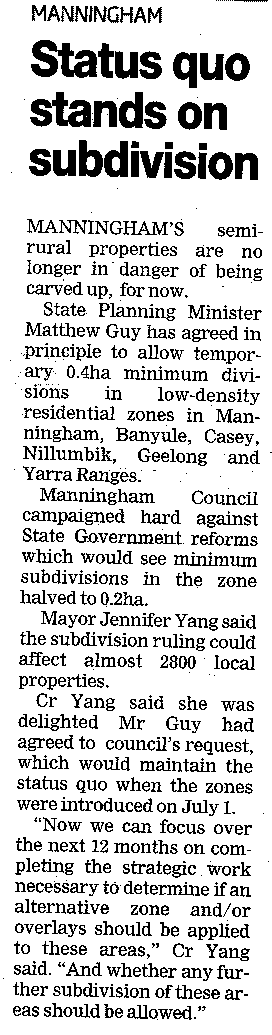
Update 3 July 2013. The council wins a temporary victory. Please see the news article below. There are a few important points. First, the state government has conceded that Manningham council needs time to review and adjust planning policy and procedures. Second, the delay is temporary. The state government is determined to allow the subdivision of these larger blocks. And the concern Manningham council about the subdivision of these large blocks, i.e. that form a buffer between the urbanised areas and the green wedge still needs to be addressed. Manningham council will need to carefully review each request for subdivision.
From Manningham Leader, page 5, July 3, 2013.
12 June 2013. (Updated 03 July 2013.) | |
| Views: 1559 | Added by: Blogger | |